I am Zachary Pratt and this is where I will share all my hiking adventures with friends as I conquer everything in my way.

Monday, July 1, 2013

Sliping the slide on a hot day


So what's is better to beat the heat then hikes?


Well sitting pool side for one but Saturday, I decided to head up to a old favorite that Noah and I did last year with a couple of my friends.

Franklin falls is pretty much a hidden jewel. It rest quite literately under I-90

Franklin Falls it self

That bridge is I-90
 
Passing over the highway, you'd never even know that it was there.
 
We actually cheated on this one as well. The trail really begins at the Denny Creek campground but because we're sneaky, I know of a location about 1/2 way up the trail where the trail almost bisects the roadway. So starting out was/makes it generally easy.
 
If you're gonna do this hike, watch out for the massive amount of Devils Club (or Devils Walking Stick as I have seen). Devils Club is a real nasty plant that looks pretty innocent but the underside has spikes on it that are not so forgiving.
 
 
One of the many plants. If you look at the stem, you'll see why they're not something to mess with.
 
Any who, we finished that hike in about 40 minutes. about 10 there, 20 or so at the falls and 10 to make it back. By this time, we all could feel the temperature and humidity going up and so we decided on our second option, go to the Denny Creek water slides and so we took off.
 
Meandering down the road and turning into the Denny Creek campground, we found parking in the madness and started to our destination but not with out pictures at the Denny Creek Bridge.
Looking at the water above the bridge

So this isn't where the slides are I'd image
 
 
So walking up the road about a 1/4 of a mile and you hit the actual trail and then it begins. The trail it self isn't really to technical and is very family friendly. I saw many family's with young ones walking along the trail.
 
About 3/4ths of a mile in, you hit a foot bridge over the creek again. Nothing to spectacular.
 
Lot's of moving water

Tony and Sam

The Girls taking a break
 
 
There is no real length to the actual water slides, the route is actually made to go to high country lakes. I would say to get the slides, it's about 1.5 miles and to actually get to them, there is a bit of a creek crossing. Before that comes though, you come to something pretty cool/unexpected.
 
I-90 east goes right over the trail

We think this tree got blasted by lightning
 
After the overpass and tree, you pretty much slog up wards for not to much time before you begin dropping back down and finally reach the slides.
 
Now before I show you pictures, these aren't like water park slides, these are slabs of granite that have the creek flow over them at such a rate that when you sit down in a shoot, they carry you into the pool at the bottom. Sadly I didn't get any video or pictures but I was having to much fun in the actual slides themselves to do so.
 
So on the right side of this photo is where you slide down, doesn't look like much but it gets you going and shoots you into the pool at the bottom

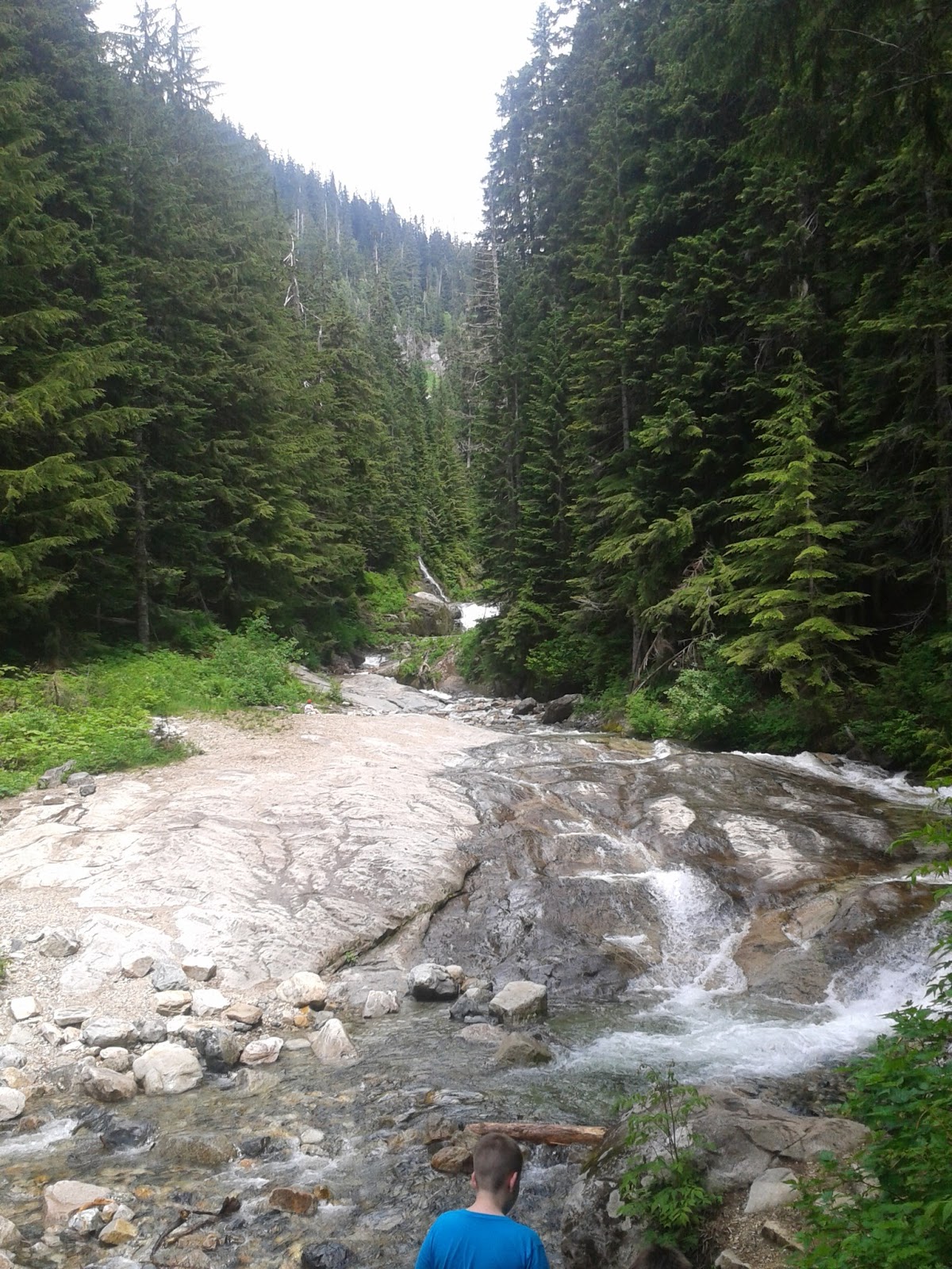
Pretty water fall just up the trail.
 
So we pretty much played in them for a good hour or so before we decided to head out. Going back was easy.
 
 
So all in all, 2 really easy hikes. Both can be done with little kids, and are enjoyable for adults a like. Keep an eye on each other because the water is snow melt and is COLD! but as soon as you get use to it, it's only a little numbing.
 
Check us on Facebook at
Obviously on the blog and also remember to
 
Keep Calm and Climb on


Sunday, June 23, 2013

Tahtlum peak

Someone once told me a "motivational quote" that goes like this

"Work hard, Keep your head in the game and if someone gets in your way... Tell them you don't give a DAMN"


Well that had to get me through this hike.

As some may know, we had been planning on doing Mount St. Helen's on Sunday but the weather effected that plan and we decided against becoming charcoal. Our next idea was Camp Muir at the 10,000 foot level on Mount Rainer. When looking at the Crevasses on the mountain  we said no. The counter option was 3 main peaks just off of Chinook Pass. A few weren't name but what I could pick up, they were Naches Peak, Tahtlum Peak and the last one being an unnamed peak that apparently has only been climbed about 3 times and with good reason.

We arrived at Chinook Pass at about 11:30 AM. It was an absolute beautiful day for a hike and there was surely snow in the hills. Me being me, I have never used an Ice Axe before but I would learn how to real fast!
The "Unnamed" Mountain off in the distance

Naches Peak

The Center pointy one is the one we actually got to
 
Hiking party before
 
We began through all that snow. If you can't tell.. Even at 5,430 feet there is still a ton of snow and yet, we didn't have to use Crampons but surely the ice axe. If you've never used one, the process is actually very simple.
 
Using it as almost a trekking pole while walking against a mountain side you dig the spike in while holding the top of it(which includes the pick and Adze)(Pick pointed backwards) and kick step (make your self steps in the ice) along your way. I've included a few diagrams for reference.
Ice pick Diagram

How to correctly walk on a hill side.
 
 
Now getting a description of how to do it, but let me show you what we were walking on.
 

Yea... We walked by that

We came along that ridge and you can see the road below
 
 
Believe it or not, the kick stepping was a lot of fun. Sketchy at times but fun in general.
 
At this point, we had realized that we had forgot one very important thing... We forgot sunscreen. Thankfully, we met 3 skiers who lucky had some sunscreen and shared it liberally with us even though we were already burning on the bright snow.
 
After talking with the skiers and finding that they had been in that back area about 80 time in the past 30 years or so, we headed off on our hike. We began to gain elevation again which was a problem because we found our self's summiting a smaller peak. In all attempts to find a Glissading route down, we ended up having to rock climb down.
 
Before I continue, Glissading is something that not man people know. The "Dictionary" definition of"Glissading is to slide in a standing or squatting position down a snow-covered slope without the aid of skis". My definition is as simple as extreme sledding. Basically, you sit on the snow, and slide down using the ice axe as stopping mechanism by simply leaning on it.
My glissade route and Marie's off to the side
 
Climbing down rocks and such we came to a very strak realization.. We had to go up a huge mountain and the ridge we were to have used wouldn't allow us to go to our original destination. The only thing that made sense was find the least sketchiest route.
We're headed to the closest one after seeing the amount of snow along the ridge line

Annnnnnd Up we go
 
 
And so the upward slog begin. Through the snow which I equated it to the last slog of Mount St. Helen's, with out the sand. I myself got about half way up and began to have problems. The vertical climb was getting to me and that normal for anyone really. The last 300 to 400 feet are the hardest because of the fact that it is so close and so far away. I had to take a break and kept fighting with myself if I could do it or not. Then, with hearing that the other 2 in my hiking party had been just at the summit and I lit some serious fire under my ass to get to the top.
 
And finally after slogging, this is what I was rewarded with
Waaaay off in the distance, is Mount St. Helen's

Little sideways but Vertigo Sucks

Mount Rainer in hiding
 
We only stayed briefly because of the on set of the clouds. We took the low route across the valley below us to try and save some time by Glissading. We only had a few upwards climb this time but thankfully, we only had one or two. We finally got back to truck.
 
All and all, I may have been a bit sadden by not climbing Mount St. Helen's but at the same time, I was introduced to many new level Mountaineering skills that I can hopefully use more often than not.
 
As for Tahtlum peak, well, she tried to shake me but in no way did I give up. If you're up for a good trail finding way and are willing to kick your self all the way to the top than this one is for you in full.
 
Hope all of you enjoyed this post as always. I also have a new rule for you all which will be posted on the rule page in bit but until than remember
 
Keep Calm and Climb on
 

Friday, June 21, 2013

Laws of the land

So when we take our long walks in the woods, we've noticed a few things that have become almost "absolute" laws for us. This is a post that will be continuously updated when we make new laws but for now, we have 3 main laws to lay down.


1.) Tripping on a garter snake is the worst way to die.

This is very simple. Image if you will, walking along a trail. With out any notice what so ever, a garter snake slitter across the trail, trips you and you happen to fall into the ravine, of the cliff or long drop to the side. We've both agreed that it would be the absolute worst way to die and weirdest thing to find on an obituary.

The common culprit.


2.) Girls always are going up when we are going down.

I don't know if they are timing it or what be but every hike we do, there is always girls coming up as we go down. Never going down as we go up.

You don't get a picture

3.) Lake Serene is a must.

Dubbed the "hike to heaven" by us and for a good reason. As in our first blog, the hike is pretty much like going to heaven and that is self explanatory.

The lake it self

Mount Index high above.


4.) An Ice Axe is needed everywhere
 
 
Even during the summer time, I'd use an Ice Axe. They can be used for lifting, leverage, balance, saving you, bottle opener, trekking pole and a bunch of other useful stuff.
 
 
With every hike, we'll have new rules and such to add so don't expect this post to just be one and done.
 
Thanks for reading as always and remember
Keep Calm and Climb On

Friday, May 31, 2013

Hike to Heaven

Here's the first entry!(Pictures at the end)


So over Memorial day weekend Noah and I decided that our hike would be dubbed "The Hike to Heaven" or as I better put it, Noah's peace spot.

We left our camp ground around 8:00 Am and got to the Lake Serene trail head. After stretching out, which we both knew was a good/needed thing to do, we began. The you start by following an old road lined. We crossed a series of minor tributaries, which I wouldn't even consider that because one could simply jump over them with little problem. At 1.7 miles, just after leaving the old roadbed, come to a signed junction (elev. 1200 ft.). The Y turn was funny for us because we were greeted with an unfamiliar knocking and with a little looking, we found a woodpecker pounding away on a sign. Why they do things like that is beyond me. We had to decide at this point, do we go straight to Serene or do we do Bridal Veil Falls first?

Well Serene won, so we carried on. We kept on the main trail, dropping a little into a ravine which lead to a crossing of  Bridal Veil Creek on a "well-built bridge" which means rock hopping, and then began climbing. The trail has a nasty tendency to use rocks, wood and roots as steps in the 23 total switch backs, which is no small feat by any means! While climbing the switch backs, we took a long sweep east - then a long sweep west - and gaining about 1300 feet in about 1.5 miles from the Creek. When we finally broke the tree line, the fun began. When you get to this point, you are able to turn and take in a stunning views of the valley below as well as out to Ragged Ridge and other peaks of the new "Wild Sky Wilderness". 

We continued up the trail, stopping to take pictures of course. We passed the spot where I tried to fall of the mountain the year before(a combination of poor shoes and snow) and relived that scare with a friendly laugh and after a little more walking, we arrived in "Heaven".

Now one thing about Serene at this time of the year is that it is covered in ice. I would image that being tucked away in the mountains and surrounded on 3 sides and mostly in the front, doesn't leave very much time to melt the ice off but all the same, I think the ice makes it that much better.

While there, I got to teach Noah a bit about hiking in the snow. When going up, you always want to kick your feet in as far as you can if you don't have crampons or poles and while going down, you want to dig your heel in as far as you can because if you start to fall, all you do is pitch back and you land on your butt and are fine. That was fun. We had our lunch beneath the towering rocks above of Mount Index. Me and Noah both agreed that if something were to cause the rocks to slide and we were there, dying to the monolithic rocks would be a respectable way to go.

We decided to head back down because of the rain and time. Would have loved to stay but stuff is always there to do back at the bottom. We traversed the switch backs down and decided to take the Bridal Veil Fall trail. We expected the trail to be easy, only being 0.5 miles but BOY was it not!!!
Lots of stairs and traversing. We arrived at the falls and at this point, I had to put my jacket on because the falls were in full force, dousing the trail in water. After taking that in, it was a quick run down the trail and we arrived back at the trail head.

LETS DO IT!


Little wood pecker

After the Switch backs, just breaking the trees.

Not bad

The reason we are here.

Mount Index high above

I almost died here

Noah and I having a picture

Bridal Veil falls


And that is about it.
 
With this being the first post and all, there will be some issues. Let me know in the comments or on Face book on what should be changed or added! Suggestions will be greatly appreciated!!
 
Here's to more hikes and as we say on the mountain
Keep Calm and Climb On!

Wednesday, May 29, 2013

And so it starts

Hello there everyone

My name is Zachary Barlow and this is a new blog I am starting that will be high lighting all my hikes I do in collaboration with my good friend, Noah Hebert. It won't just be him though. This new blog will give me an excuse to post all of my hiking information and Noah's (I just have to figure out how to give him co-control).

This won't just be a small thing as well. After awhile, our hikes will get bigger and bigger and hopefully our reader's will enjoy our content more and more through out the entire time we use this method of posting.

If you have any suggestions on where we should hike, what we should do with this group or you want to share your own hiking experience's with us, I hope to get a web page going with fan posts to share there specific adventures but that is all in due time.

Our first hike that we'll talk about will be Lake Serene and that will come as soon as I can make it happen.

Till then, Keep Calm and Climb On